PhD thesis. “Architectural Design at the Time of Anthropocene: Reporting from the Critical Zone”. A thesis submitted to The University of Manchester for the degree of Doctor of Philosophy in the Faculty of Humanities, 2022
The environmental crisis changed considerably the daily practices of landscape designers at the time of the Anthropocene, renewing attention to granular elements such as chemicals, sand, nutrients, water, earthworms, fungi, etc. The habitability of our planet depends on these various entities and their entanglement. With the “intrusion of Gaia” (Stengers), two visions of nature collide: the anthropocentric view, which perpetuates an idea of nature as a passive body, a background of human activities, and the cosmopolitical view, whose approach aims to better understand this intrusion of Gaia. This thesis first identifies which ideas, tools, designs and visual regimes contribute to perpetuating an anthropocentric vision of nature, and which ones, conversely, construct the cosmopolitical approach, through the variability, the agency, the complexity and the plurality of natural entities. However, this approach is yet to be developed. This is why this thesis aims to bring new, cosmopolitical insights into what a landscape is, what composes it.
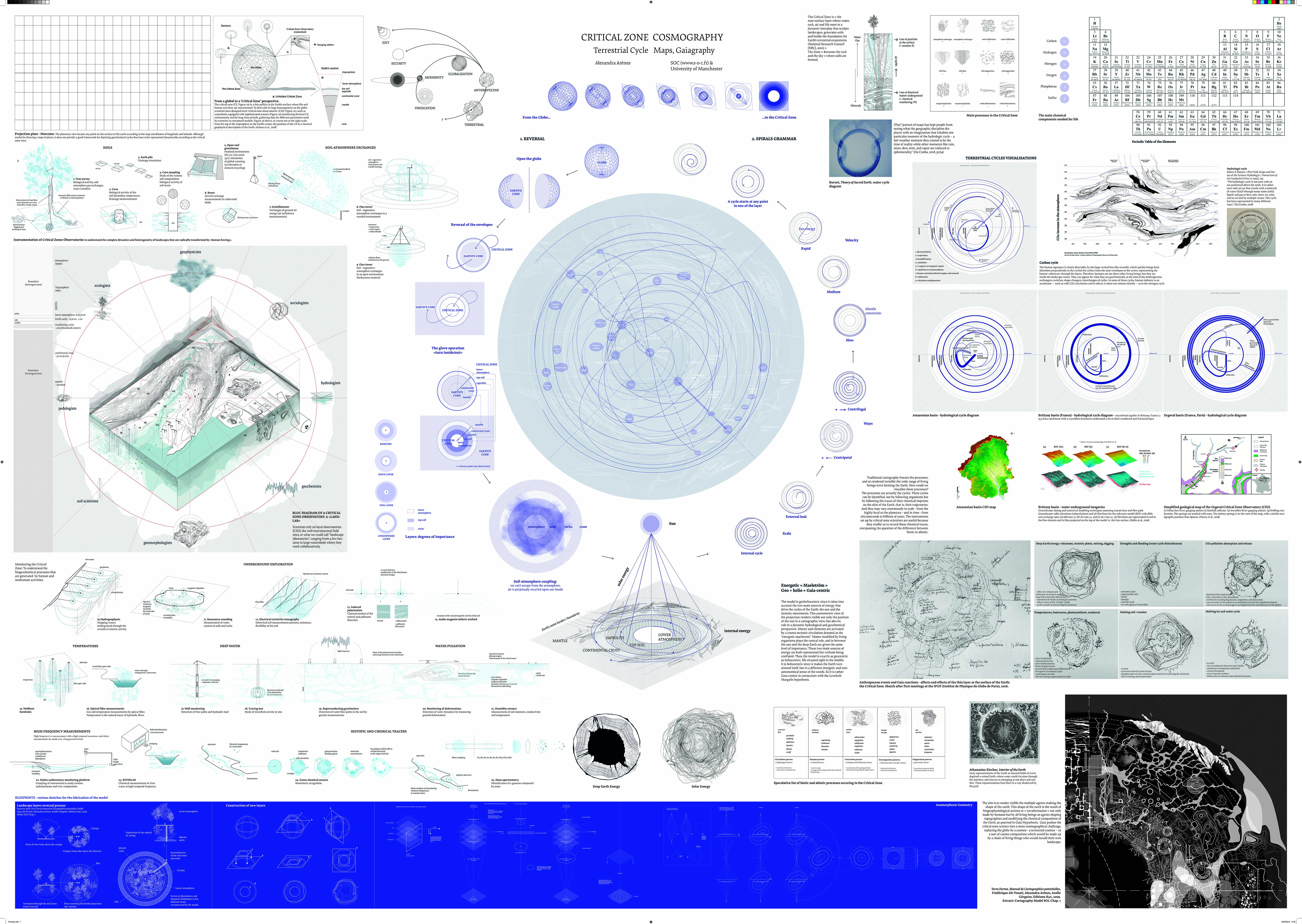
To address these questions, I have undertaken empirical fieldwork using ethnographic methods, following scientists of a specific branch of earth sciences called the Critical Zone (CZ). The specificity of CZ science is the instrumentation of landscapes. In observatories, geoscientists decompose landscapes, through their observations of the soil, the rivers, and the atmosphere.
//////Download PDF
This thesis examines how scientific instruments and practices monitor various natural features over the long term, in order to trace their unexpected trajectories. The dissertation shows how this knowledge can bring a new understanding of territories and the Earth, more attuned to the different cycles and their overlapping dynamics.
The thesis also experiments with alternative mappings to capture the complexity of the composition of the Critical Zone. These maps, or visualisations, shift the anthropocentric view (which divides the territory and visualises it as a surface to be constructed), to a cosmopolitical view (a view from within, which deconstructs the traditional cartographic frame of reference to create a new one that takes into account the depth of the soil and different cycles). The contributions are twofold: a more nuanced knowledge of what is called ‘nature’ through visual tools, and the production of meticulous cosmograms related to the scientific object Critical Zone. It is this ensemble that can be named ‘gaia-graphy’. The production of these maps contributes to a better understanding of the dimensions of this Critical Zone and can bring a new understanding of landscapes in architecture. It can also have an impact on architectural practice and its transformative agency in the new climatic regime.
Ressources
Google scholar ; ORCID
Book
Article (peer-review)
Articles (non peer-review)
The soil map of the Strengbach Critical Zone Observatory, in OASE 110 Soil, 2022
Exhibition (selection)
« Les sols et sous-sols d’Ile de France. Enquête, ateliers et cartes ». Collective exhibition Bienale d’Architecture et de Paysage, Versailles. Founded by Institut Paris Région. May – July 2022
Lectures (selection)
“Mapping the Critical Zone,” Monsoon [+ Other] Grounds Symposium, University of Westminster, London, 2019.